Evacuation orders, warnings planned for burn zones as storm soaks Southern California
Evacuation orders and warnings are going into effect Thursday morning for the Los Angeles area burn zones as the strongest winter storm of the season drenches Southern California.
Residents in the Palisades and Eaton fire burn zones have been preparing for several days to keep their homes safe from potential mud and debris flows in anticipation of the massive storm.
The Los Angeles Fire Department has already issued an emergency alert announcing evacuation orders for specific addresses and warnings for several areas will be in effect between 7 a.m. Thursday and 2 p.m. Friday due to the high risk of mudslides.
“These areas are recently burned and especially susceptible to heavy rain,” the Fire Department stated.
Evacuation warnings:
- Palisades Fire area: Getty Villa area, Highlands near the burned areas, Bienveneda area near Temescal Canyon Park, Reseda Blvd area/Marinette Road near Will Rogers State Park, Mandeville Canyon above Tanners Road.
- Sunset Fire area: East and South of Runyon Canyon.
- Hurst Fire area: Olive Lane in the Oakridge Mobile Home Park.
Homes in the higher-risk warning areas will be visited by Los Angeles police officers to issue specific evacuation orders, the Fire Department stated.
“If you decide to stay in your property in an evacuated area. Debris from the burn scar area and storm may impede roads and we may not be able to reach you. That is not a good scenario or situation for anybody involved,” Los Angeles County Sheriff Robert Luna said.

Evacuation warnings will also be in effect for many areas within the Eaton Fire burn zone including the Altadena areas near the San Gabriel foothills where thousands of K-Rails and sandbags are now in place.
More information and maps of all impacted areas can be found on the L.A. County Public Works website.
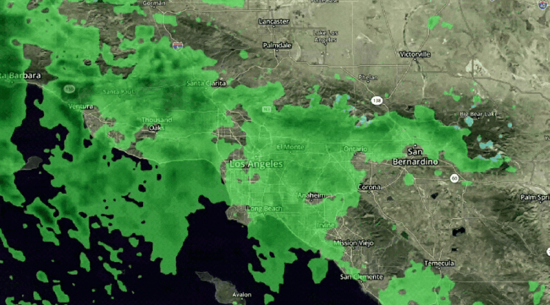
The National Weather Service predicts a “high risk of flooding and burn scar debris flows” as the Los Angeles area is expected to receive between an inch and a half and three inches of rain from this week’s storms.
The heaviest showers are expected to fall between 6 a.m. Thursday and noon Friday, with rain rates between half an inch and one inch per hour.
Lighter showers are expected to continue Friday before drier and warmer conditions arrive for the weekend.