Rainstorm arrives in Southern California, bringing flood threats, dangerous road conditions
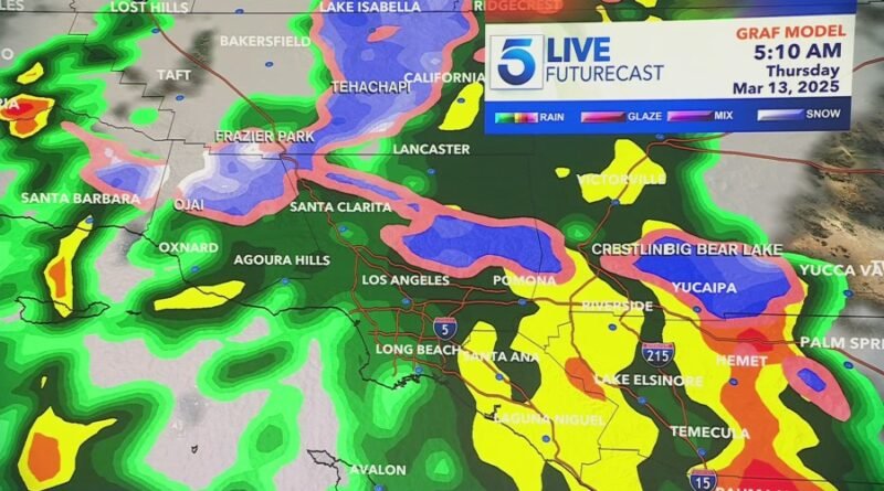
A storm system is expected to bring heavy rainfall and mountain snow to Southern California late Wednesday night into Thursday.
Heavy downpours paired with thunderstorms and gusty winds will bring a high risk of flooding to roadways and threats of mud and debris flows, according to the National Weather Service.
“The main event will be overnight tonight with a strong and fast-moving cold front traversing the area from northwest to southeast,” said NWS. “This storm will pack quite a wallop despite its short duration.”
Rain totals are expected to peak between 1 and 2 inches for the Los Angeles County coastal and valley regions, with up to 4 inches possible in the mountains and foothills.
A Flood Watch was issued across the Southland and will be in effect until Thursday, March 13 at 6 p.m. Neighborhoods that had a high risk of mudslides and debris flow dangers were placed under evacuation warnings and orders.
-

A significant rainstorm is expected to peak fron late Wednesday night into early Thursday morning, bringing slick road conditions and snowfall to higher elevations. (KTLA) -

A significant rainstorm is expected to peak fron late Wednesday night into early Thursday morning, bringing slick road conditions and snowfall to higher elevations. (KTLA) -

A significant rainstorm is expected to peak fron late Wednesday night into early Thursday morning, bringing slick road conditions and snowfall to higher elevations. (KTLA) -

(National Weather Service) -

A significant rainstorm is expected to peak fron late Wednesday night into early Thursday morning, bringing slick road conditions and snowfall to higher elevations. (KTLA) -

A significant rainstorm is expected to peak fron late Wednesday night into early Thursday morning, bringing slick road conditions and snowfall to higher elevations. (KTLA)
“We have a lot of cold air coming and that’s what will cause all the instability and the threat of thunderstorms,” said KTLA meteorologist Vera Jimenez. “Anytime we talk about rainfall rates that are at least half an inch per hour, we see the threat of flood. With this particular front moving in, we’re seeing not just half an inch of rain per hour, but as much as three-quarters up to an inch of rain per hour and that is what has everybody on guard.”
Snowfall is expected at elevations above 3,000 feet with winds between 45-65 mph. A Winter Storm warning remains in effect through Saturday, March 15 at 6 p.m. Icy, dangerous road conditions could affect drivers traveling on the 5 Freeway near the Grapevine, the 14 Freeway from Acton to Palmdale, and Highway 33 north of Ojai.
Drivers are advised to take extreme caution as strong winds and heavy snow potential will bring reduced visibility.
“Especially as heavy rain approaches, I urge all Angelenos to heed all weather warnings,” said L.A. Mayor Karen Bass. “This storm has the potential to cause impacts in burn areas but also neighborhoods citywide.”
Residents are advised to avoid traveling during the storm if possible. If traveling must be done, drivers should be cautious of any downed trees or power lines and flooded roads. Packing an emergency kit in the car is advised.
“That flood watch doesn’t just include the mountains and the foothill or burn scars, but it’s actually widespread, so anywhere in our five-county region, you will be under the threat of flooding,” Jimenez explained.
Anyone who sees a blocked or flooded roadway can request service through MyLA311 or by calling 311. Power outages or water main breaks can be reported to the L.A. Department of Water and Power at 1-800-DIAL-DWP or online here.
“Thursday will be a mixed bag of weather with showers and thunderstorms and periods of heavy rain and lower elevation snow, but some sunny breaks as well,” said NWS. “Light showers are expected Friday then dry and warmer over the weekend.”
Another weaker storm is expected between Friday and Saturday bringing light rainfall chances but skies should clear up by Sunday, weather officials said.